Maps of the Karabakh conflict: the situation on the ground according to Armenia and Azerbaijan


The Ministries of Defense of Azerbaijan and Armenia have simultaneously published maps of military actions in the Karabakh conflict zone showing who is allegedly in control of specific districts and settlements, as well as where the main fights are taking place.
In most cases, these maps don’t coincide.
Reuters also provided a map of the Karabakh conflict zone during the period after 1988 up to 2019.
It shows districts abandoned by ethnic Azerbaijanis as a result of the war in the beginning of the 1990s.
According to Reuters’ information, since fighting in 1988 up until 2019, around 30,000 people have died on both sides, most of them military servicemen. This number doesn’t include the number of victims of military actions that started on September 27 and are currently continuing. Expert data states that several thousand people have already died during the escalation.
• Karabakh, fighting and negotiations. Hourly updates, video/photo. Oct. 25
• ‘Peace in exchange for territories’ – an opinion from Baku about the seven regions around Karabakh
• “War for Azerbaijan is a means to remove compromise” – Armenian political scientist
• Who will help solve the Karabakh conflict – Washington or Moscow?
Maps published on October 24, 2020
Five maps of military action as of October 24, 2020, version provided by the Ministry of Defense of Armenia
• Blue arrows — territories experiencing combat
• Red arrows — direction of retreat of Azerbaijani armed forces
• Orange marks territories under control of Azerbaijani armed forces.
Ministry of Defense of Armenia warned that military actions still continue, there are local fights going on, and correspondingly, the map is also changing actively.
Interactive map of military actions as of October 24, 2020, version provided by the Ministry of Defense of Azerbaijan
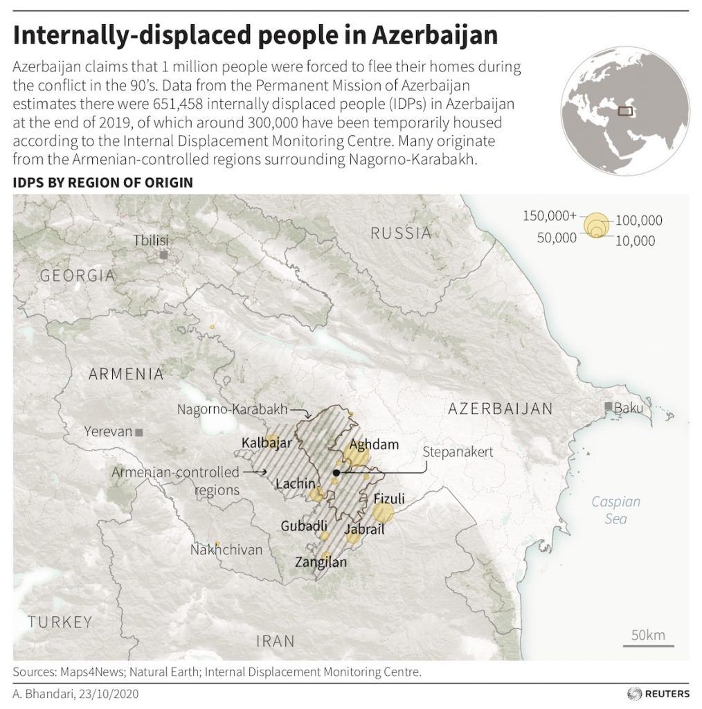
Reuters: Map of the Karabakh conflict zone as of 2019. Data on internally displaced ethnical Azerbaijani persons
According to the permanent representation of Azerbaijan in UN, by the end of 2019 there were 651,458 internally displaced persons in Azerbaijan. Yellow marks the districts abandoned by ethnic Azerbaijanis after the Karabakh war of 1988-1994.